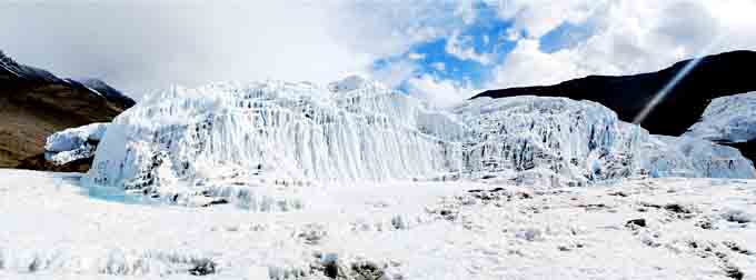
• Skip to main content
  • Skip to footer

Stone Aerospace

Smart tools and systems for exploring the frontier

  • Home
  • About us
    • What we do
    • History
    • Design philosophy
  • Projects
    • BEAGLE
    • PARTI-Pucks
    • Thor
    • PROMETHEUS
    • ARCHIMEDES
    • ARTEMIS
      • Description
      • Field notes
      • Photo gallery
    • VALKYRIE
      • Description
      • Field notes
      • Photo gallery
    • ENDURANCE
      • Description
      • Field notes
    • DEPTHX
      • Description
      • Field notes
  • News
  • Employment
  • Contact us
  • Stone Aerospace in One Page

Stone Aerospace

October 6, 2009 By Stone Aerospace

ENDURANCE: Mission 2: October 6, 2009

Antarctica
Reporting from McMurdo Station

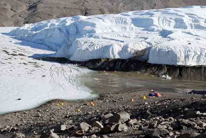
The Endurance 2009 mission is underway!

Chris Flesher and Vickie Siegel left the States on Friday night and arrived in New Zealand on Sunday after a twelve-hour flight (ponder that one for a second…). From there it was on to Christchurch, the city on New Zealand’s south island where the United States Antarctic Program (USAP) stages the logistics for running the McMurdo and South Pole research stations.

The next day we went to the Clothing Distribution Center and were issued ECW (Extreme Cold Weather) gear. This is all of the stuff that keeps one alive in Antarctica—things like long underwear, thick socks, snow goggles and so on. The two most important items are the voluminous parka, fondly referred to by all as “Big Red”, and the super warm “bunny boots” (more on those later). We received the requisite flu shots (disease spreads quickly in Antarctica’s close indoor quarters) and sorted luggage for the flight to the ice the following day.

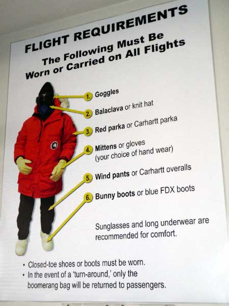
This poster shows some of the cold weather gear that researchers and support workers get from the Clothing Distribution Center

On this CDC visit we were reunited with Maciej Obryk, good friend and Endurance teammate from University of Illinois at Chicago. Boisterous greeting and catching up followed and Maciej introduced 3 new folks we would be working with at Lake Bonney this year: Jim Olech, who will be assisting Maciej with his Long Term Ecological Research (LTER) at the lakes this year; Loralee Ryan, who, after a brief stint of helping the Endurance team, will be working on John Priscu’s Limno team; and Emma Steger, who will be the East Lake Bonney camp manager this year.

After a group dinner we were off to bed, excited to be heading back to the Ice the next day. We all awoke around 4:30 am to a chilly, dark morning and hopped on the shuttle back to the CDC, where the C-17 military jet leaves for McMurdo. We groggily finished sorting our luggage for the flight, weighed ourselves and our baggage for the flight manifest, sat through some briefings, ate breakfast and generally milled around before the flight. Despite the early hour, there was a festive air in the crowd of 130 support personnel and scientists heading down to the Ice. Chris likened the scene to a really big family reunion, one where you don’t know everyone but you recognize many faces, do a lot of gabbing and catching up, and find that everyone is generally ready to enjoy the times ahead.

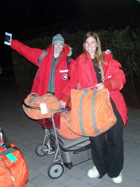
Emma and Loralee break in their Big Red parkas while waiting in line for flight check-in.

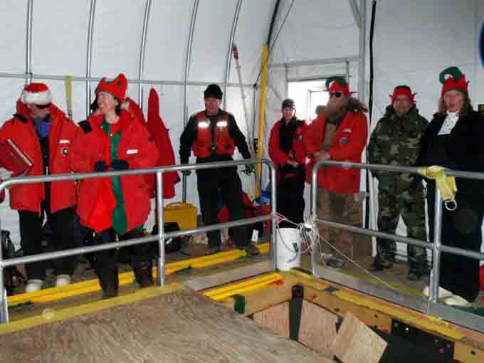
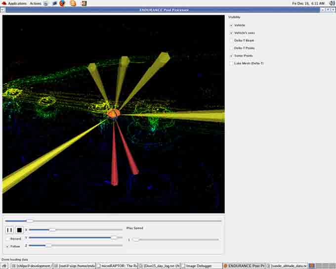
As of this writing, we are about halfway through the 5 hour flight. About a third of the group is snoozing. Others are reading, rocking out to their mp3 players, or pursuing half-shouted conversations over the engine roar. More briefings await us this afternoon and there are trainings to attend tomorrow. That done, we will be reunited with the Endurance robot, which has been safely stored away in McMurdo over the Antarctic winter, and work will begin!

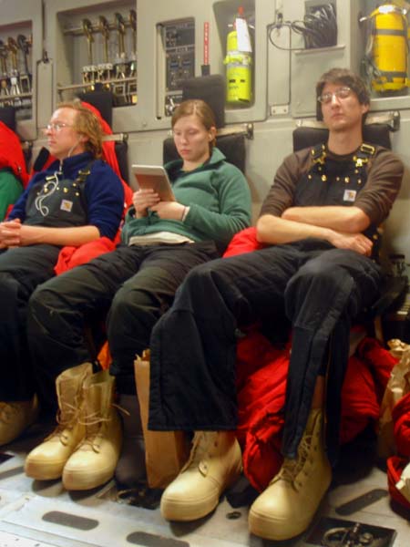
Jim, Emma, and Chris employ different strategies to pass the time on the 5 hour flight.

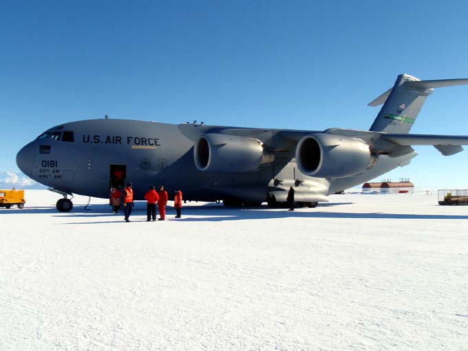
The C17 has landed; we are on the Ice.

Reporting by Vickie Siegel

December 24, 2008 By Stone Aerospace

ENDURANCE: Mission 1: December 24, 2008

West Lake Bonney, Taylor Valley, Antarctica
Reporting from Blood Falls Basecamp

Today we decided that we would use our last day of mission runs to approach the glacier face for one final time this year. While we have been able to map the glacier surface with the DeltaT over the past several days, the murky water has prevented us from taking the photographs we had hoped to mosaic and overlay onto the 3D surface map we have. Still eager to get some good images despite the poor visibility, Kristof suggested sending the bot to within a few meters of the glacier, closer than our previous stand-off distance. Maybe closer to the face we would be able to get some good images, we hoped. To minimize the risk of any bumping or snagging hazards we decided to visit a flat, uncomplicated stretch of the face that we had spotted in the sonar data from the past few missions.

Since the navigation systems lost lock the last time we approached the glacier close-up, we were cautious in our approach this time. The bot continued to function properly during the entire mission but unfortunately the poor visibility in the water thwarted our attempts to take photos, even at our closer range. The bot returned home and we pulled it out of the icy drink for the last time this year. With our last mission now completed, all that remains for us is to pack up our equipment, break down the bot house and return home to finish processing all of the data that we’ve collected. Goodbye Lake Bonney—we’ll see you again next year!

The lake’s currently cloudy water made photographing the glacier face practically impossible. Still, it is possible to make out vague shapes and variations in color in these two photos taken by the bot’s horizontal-facing camera today.

Here is the first image from above, digitally processed to show more detail.

A parting shot of our camp a Blood Falls before we start packing up.

Reporting by Vickie Siegel

December 23, 2008 By Stone Aerospace

ENDURANCE: Mission 1: December 23, 2008

West Lake Bonney, Taylor Valley, Antarctica
Reporting from Blood Falls Basecamp

In this morning’s group meeting we discussed the possibilities for today’s mission. We determined that if we gave the bot a fairly ambitious mission plan today we might be able to get the rest of our DeltaT glacier scans done by the end of the day. We decided to go for it.

Soon after starting to go through the bot’s pre-launch checklist we heard someone hail us on the helo communications channel of our radio, accompanied by the distant beat of a helo rotor coming up the valley. We had been informed that there might be visitors today, so we figured we would be giving the grand tour to some folks from McMurdo or Scott Base (New Zealand’s science station on Antarctica). The helo landed outside the bot tent and the visitors came in. To our surprise, however, these were not the normal kind of visitors we had seen before. These folks were decked out in red and green, jingle bells, and Santa hats. After marching into the Bot House and singing us a Christmas carol or two they presented us with gifts. The boxes contained the best thing you could bring to a bunch of researchers working on a frozen lake for over a month: food. There were fresh baked cookies, bread, and candies and, one of the most valuable and rare things in you can wish for here in Antarctica, fresh fruit.

Santa’s jolly elves gather around the moon pool to sing us a carol.

Our jolly visitors departed, off to spread cheer to the other field camps, and we munched some cookies and got back to work. We completed the checklist and sent the bot on its way. There were no snags today and the bot succeeded in doing a continuous sonar sweep of the remaining glacier face. Chris took the bot’s trip home as a chance to experiment with running the vehicle at higher speeds to find the most power-efficient speed. We took the bot up to a whopping .25 meters per second!

This image is a panorama south to north across the 1 km wide glacier face.
We got more than 100 million sonar hits to build the map; only about 5 million
are shown here to keep the file size reasonable. In the center portion it appears that the glacier is actually floating on the lake (there is an undercut cave at the bottom that runs about 1/3 the length of the image). You can also see moraine deposits at either end. This is a 2D end-on rendering of the glacier—the data are full 3D and we will be generating some “fly through” videos with the UIC electronic visualization lab over the next month that will give life to this and to the lake chemistry data. Click here for the largest version (8Mb).

Reporting by Vickie Siegel

December 22, 2008 By Stone Aerospace

ENDURANCE: Mission 1: December 22, 2008

West Lake Bonney, Taylor Valley, Antarctica
Reporting from Blood Falls Basecamp

Today we continued our glacier exploration, this time doing a combination sonde drop and glacier-mapping run in the southernmost area of the glacier face. The mission plan took us first to the delta south of the glacier face where we did a few bonus sonde drops in the shallow waters there. Mission control had to do a little bit of maneuvering to avoid some underwater moraines.

From the southern delta, the bot traveled north along the glacier, scanning it with the DeltaT sonar. Things went smoothly until Leah reported that the fiber was feeding out, not in, meaning that the bot was snagged. We managed to unsnag by diving the bot down and then moving to the side to get out of the snag zone before continuing. As the bot proceeded to head home after that it snagged again and this time the diving trick didn’t work. Instead, mission control directed the bot to back up past where, calculated from the distance markings on the fiber, they estimated the snag to be. After backing up, we tried diving again and managed to free the bot. Even with the extra time and battery power this delay consumed, the bot returned home after the six and a half hour mission. Now we have some great 3D data from the southern edge of the glacier face. Our job over the next few days will be to continue scanning the north end of the face.

This panorama shows the complex surface of the Taylor Glacier face on the surface. In a few days we’ll learn what it looks like underwater, too.

Reporting by Vickie Siegel

December 21, 2008 By Stone Aerospace

ENDURANCE: Mission 1: December 21, 2008

West Lake Bonney, Taylor Valley, Antarctica
Reporting from Blood Falls Basecamp

Recovered and ready to try another approach to the glacier face we sent the bot to the middle section of the glacier face, just south of our run on Friday. This would take the bot into the iceberg zone so the plan was to stop the vehicle periodically and do a sonar sweep to look for the subsurface portion of the icebergs. If we could, we would drive the bot into the channel between the glacier face and the icebergs.

To our surprise, the sonar scans showed nothing under the ice in the area where icebergs stood 2 meters high on the surface. It would seem that either the warm water entering the lake near the glacier has melted the subsurface portion of the bergs or that the surface bergs were formed ice that spalled off the glacier face never broke the surface of the lake ice in the first place. In any case, we were happy that this hypothesized snag hazard didn’t exist.

The water continues to be murky so we were unable to take any visual images of the glacier but we racked up a ton of sonar data on the glacier face. With today’s data and the data from our first glacier mission combined, we have mapped half of the glacier face so far.

A screenshot of the visualizer program that shows us where the sonars are getting hits.

Reporting by Vickie Siegel

« Previous Page
Next Page »

Footer

Corporate headquarters:
Austin, Texas

Smart tools for exploring the frontier
  • Facebook
  • Instagram
  • LinkedIn
  • Twitter
  • YouTube

Copyright © 2025 · Stone Aerospace, Inc.