• Skip to main content
  • Skip to footer

Stone Aerospace

Smart tools and systems for exploring the frontier

  • Home
  • About us
    • What we do
    • History
    • Design philosophy
  • Projects
    • BEAGLE
    • PARTI-Pucks
    • Thor
    • PROMETHEUS
    • ARCHIMEDES
    • ARTEMIS
      • Description
      • Field notes
      • Photo gallery
    • VALKYRIE
      • Description
      • Field notes
      • Photo gallery
    • ENDURANCE
      • Description
      • Field notes
    • DEPTHX
      • Description
      • Field notes
  • News
  • Employment
  • Contact us
  • Stone Aerospace in One Page

Stone Aerospace

November 30, 2009 By Stone Aerospace

ENDURANCE: Mission 2: November 30, 2009

West Lake Bonney, Taylor Valley, Antarctica
Reporting from East Lake Bonney Basecamp

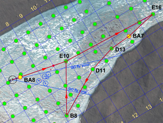
Mission Objective: clean up bathymetry gaps in the northwest quadrant of West Lake Bonney. Conduct instrument alignment patch and crossing tests.

The team was up at 9am (less than 6 hours sleep for Chris and Bill) and back at the mission planning task. At 10am Kristof delivered decimated data sets for the Narrows and the southwest quadrant shore scans. These were imported into the mission planner and work continued until 2pm. Bathymetry Mission 4 was a complicated, “gerrymandered” trajectory designed to accomplish the dual tasks of filling in the gaps in the 2008 bathymetry data in the northwest quadrant and, as well, to acquire data that would be used to calibrate local yaw, pitch, and roll for various critical mapping instruments. The main multi-beam imaging system was moved from its forward-looking mapping and obstacle avoidance position to a down look orientation for swath bathymetry mapping.

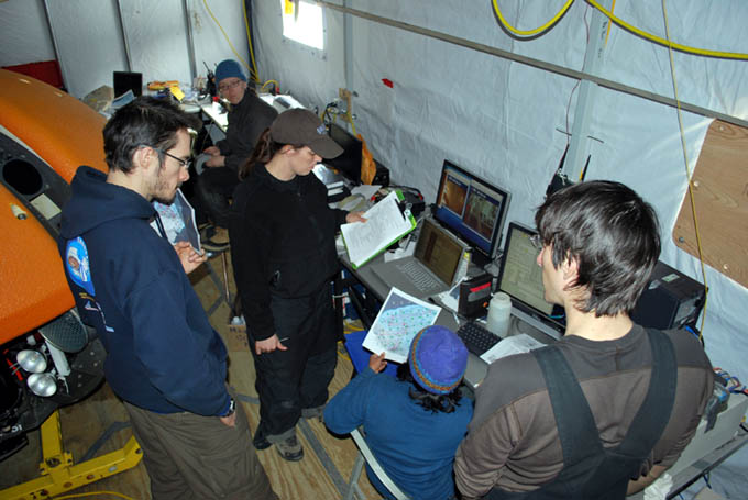
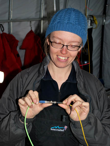
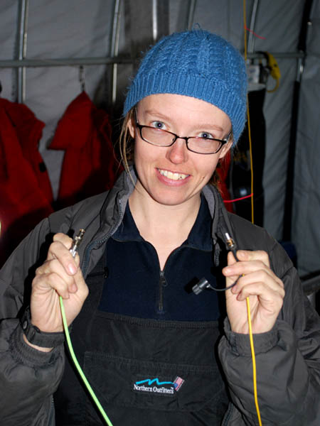
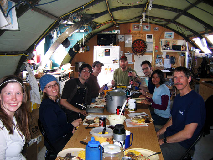
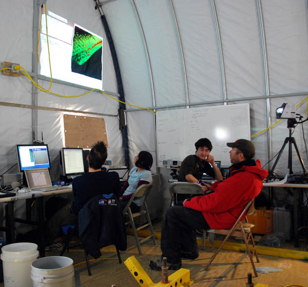
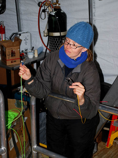
Kristof (left), Vickie, Rachel, Shilpa, and Chris go over the November 30th mission plan.

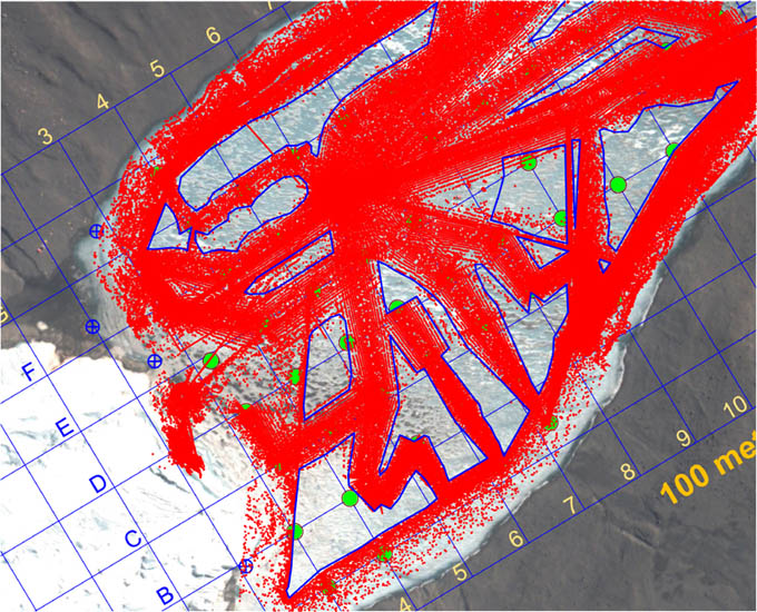
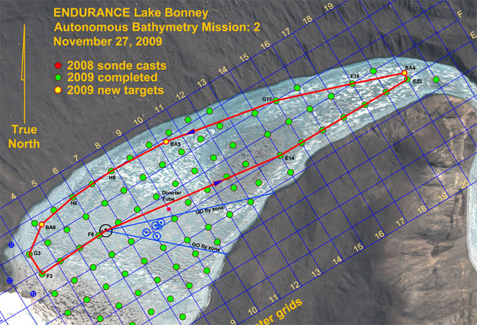
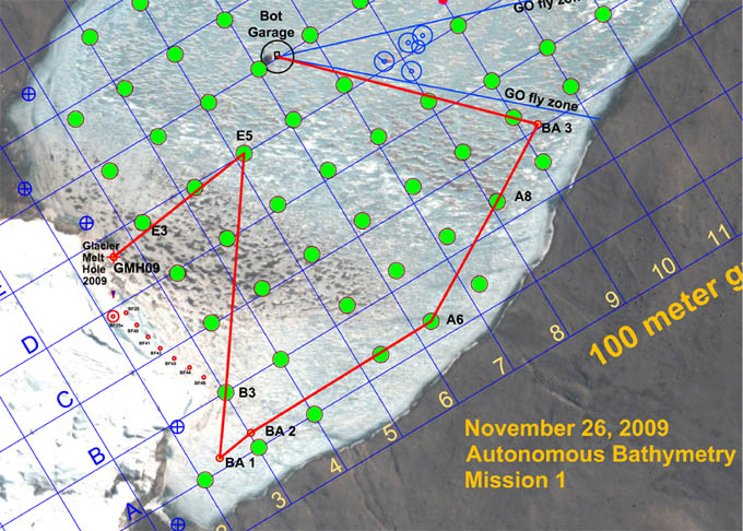
Prior to November 30, 2009 this was the plan extent of the bathymetry that has been acquired for West Lake Bonney and represents a composite of all 2008 and 2009 missions to date that collected bottom topography information. The blue polygon-enclosed areas represent gaps in the data set. Our goal was to fill these in to the maximum extent and leave no gap greater than 25 meters.

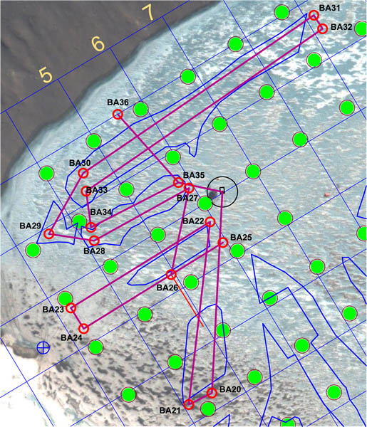
The gerrymandered mission of November 30 was meant to sweep out all of the blue polygon gap areas shown and, as well, to conduct calibration tests that would acquire data needed to align the critical mapping sensors in yaw, pitch, and roll relative to the vehicle coordinate system. The “patch” test used segments BA22-BA23 and BA24-BA25; the “crossing” test used segment BA35-BA36 in conjunction with BA30-BA31 and BA32-BA33.

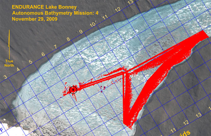
By 2:40pm the bot was down hole and on its way. As soon as it cleared the positive buoyancy test Vickie disconnected the fiber and the next fully autonomous mission was underway. Kristof took a turn out on the ice with tracking the bot in real-time. Five hours later, having run the maze-like mission, the bot found the melt hole, locked onto the light beam and surfaced on its own. The entire mission had proceeded flawlessly with a run time of 3.8 hours underwater (4.8 hours total in-water mission time). The total underwater traverse was 3,481 meters. We had, using the mission planner, conservatively predicted 27% power reserves at this point; the actual reserve was 35% at surfacing.

Vickie breaks the data link to the vehicle for the second day in a row. From this point forward the vehicle was fully autonomous.

Given that we still had substantial power remaining, the vehicle was re-ballasted for neutral running at 5 meters and sent to station F6. A series of cast tests were conducted there (fully automated drops) using a simple control filter comprised of the Profiler encoder, the Sonde altimeter, and the Doppler vertical ranging. We will later include the following additional auxiliary sensed data to the control filter: bot depth sensors (meters); sonde depth sensor (meters); nadir obstacle avoidance sonar (meters to bottom); and central multi-beam range (meters to bottom).

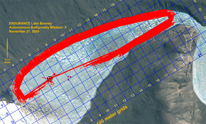
At 8:54pm the bot returned to the melt hole, locked onto the guidance light beam and rose up the hole. The bathymetry data were downloaded and subsequently plotted later in the evening. These revealed some curious behavior in the data. In the central portion of the lake we obtained nearly 100% of the intended topographic fill content we were seeking. However, in the shallows along the northwest shore the acoustic reflectance characteristics of the lake bottom were significantly different, and the valid range returns from the multi-beam comprised a narrower swath than was originally expected. The instrument in question had software selectable range gating and signal gain adjustments, but these are frequently sensitive and too much gain, which would have led to a wider return swath, would have resulted in noisier, less accurate measurements unless the range gates were appropriately set. This process, currently, is something best done by a human while observing the data feedback. It would have been caught immediately had this been a human-supervised autonomous mission, as we had until now been running. It pointed to the limitations of a robotic system in a purely autonomous setting. Silicon intelligence only responds to that which it is programmed to perceive plus a few simple behaviors driven by direct sensed and derivative data.

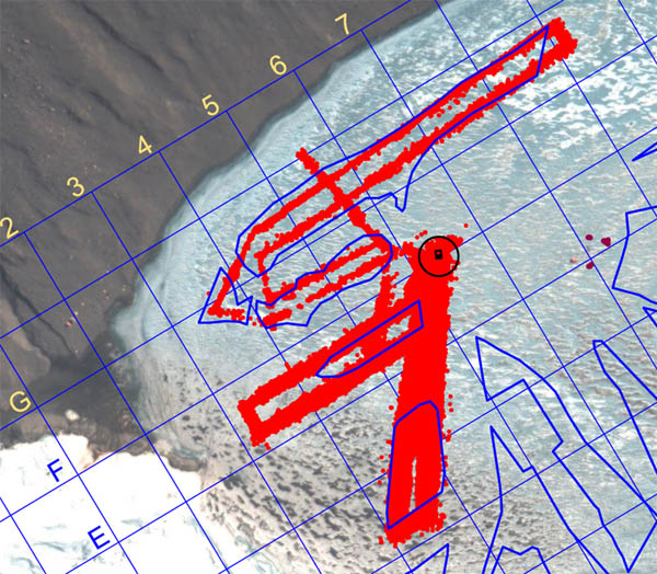
Bathymetry fill results from the November 30 fully autonomous mission. Nearly complete fill was achieved at the center of the lake; less coverage (but still acceptable) was obtained in the shallows towards the northwest shore, largely because of a reduction in the acoustic reflectance of the material in that area.

Shilpa retrieves the iUSBL transponder prior to arrival of the bot. Since the data fiber was disconnected, we tracked the bot position using the through-ice emergency beacon. Kristof, who was on duty, radioed the message to Shilpa who pulled the beacon just as the bot arrived under the melt hole.

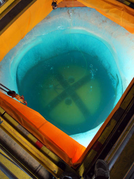
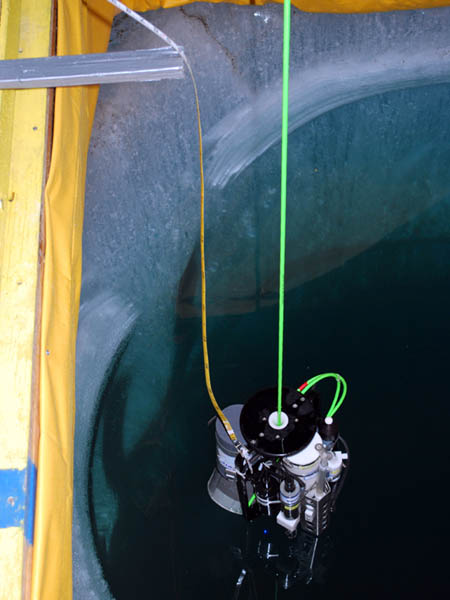
Returning home, image 1 of 3: the bot crosses the melt hole at a depth of 5 meters.

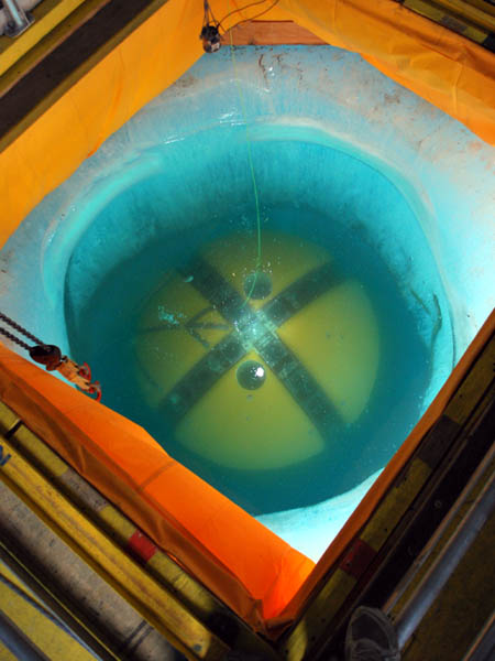
Returning home, image 2 of 3: the bot locks onto the central guide light beam.

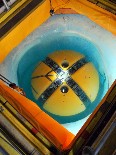
Returning home, image 3 of 3: the bot surfaces, still locked onto the central beam.

Reporting by Bill Stone

November 29, 2009 By Stone Aerospace

ENDURANCE: Mission 2: November 29, 2009

West Lake Bonney, Taylor Valley, Antarctica
Reporting from East Lake Bonney Basecamp

Mission Objective: complete the final section of lake edge scanning with an autonomous, fiber-disconnected mission (we will retain the physical fiber tether but the link will be broken at the bot house). Subsequently, perform several autonomous sonde casts at F6 to test new code that has been developed since the November 21 and 23 instrument pod grounding incidents; then a calibration of the sonde encoder.

The crew was up and eating breakfast at the Jamesway by 7:30am. A full team meeting was held at 9am to plan out the final 2009 missions. Most of these focused on the completion of the lake bathymetry and a notable re-run of the Bonney Riegel narrows mission—not because of data error but in order to gain a second, temporal, data set that would show how the chemistry measurements changed at the shallow sill separating East from West Lake Bonney (WLB) as a result of the now increasing melt runoff from Taylor glacier. The team agreed to the following remaining missions:

  • Nov 30: tether-disconnected (at bot house) bathymetry, northwest quadrant WLB
  • Dec 1: tether-disconnected (at bot house) bathymetry, southwest 1/3 of WLB
  • Dec 2: Narrows sonde re-run, with data fiber and with manually supervised sonde drops
  • Dec 3: Narrows sonde re-run (if necessary), tether-disconnected (at bot house) or mop-up bathymetry southeast quadrant behind the limno cables
  • Dec 4: pack up

The mission plan for November 29th, 2009 was fairly straight forward—a bathymetric side-look scanning run at 80 meters standoff range down the southeast edge of the lake to stitch together the previous two lake edge scans. But it involved moving through the limnological LTER zone. For security we left the data fiber attached to the vehicle (but not connected to mission control), so we again used the pivot point (tube) west of E10 to ward the fiber away from the limno cables.

The entire crew was on the way to the Bot Garage at 9:45am. By 12:30pm the mission was underway and ice-picking positive buoyancy checks At 12:35pm Vickie disconnected the data fiber. The bot was on its own. In order to keep some measure of what was happening Kristof and Bill proceeded to follow the vehicle using the thru-ice tracking system. They proceeded directly to the E16 sonde cast location (using GPS to re-locate it since the flags had already been retrieved after the surface fix was achieved). The vehicle proceeded smoothly down the southeast shore to B8, which was well behind the prior limno “no fly” zone. We were again using the PVC pivot tube (small red circle about 140 meters southwest of E10—see mission plan figure). All proceeded according to the program and at 3:30pm the vehicle returned to the melt hole with sub-meter navigation error.

Vickie prepares to free the bot.

The deed is done and ENDURANCE is running fully autonomously, without supervision from mission control.

Results of the November 29th lake edge bathymetry mission. Only 1/100th of the points acquired are plotted here.

Chris subsequently ran a few automated sonde casts at F6 to test new code that integrated several auxiliary sonar systems to augment the altimeter on the Sonde instrument pod. The remainder of the time until 8pm was used to calibrate the Sonde depth sensor. Kristof and Shilpa read off the precise descent distance (using a metric fiberglass tape) while Chris stepped the Sonde downward via software commands. Bill recorded the encoder ticks and the pressure sensor readings. With these entered into a spreadsheet we were able to develop a very accurate compensation system with which the Sonde altimeter readings, and those of alternative sonar soundings from other instruments, could be correlated. We planned to test this new concept following the December 3 mission.

With the bot suspended out of the water, the Sonde pod is lowered to lake bottom with a metric tape trailing behind. This external reference provided an absolute scale against which to calibrate several onboard sensors including the drum encoder for the spooler, the pressure sensors on the Sonde, and the down-look altimeter on the Sonde. These would later be fused in a new filter for enhanced autonomous bathymetry tests.

The planning for the next few day’s bathymetry missions meant post-processing all of the prior data (scores of gigabytes, including that from 2008), importing those into the mission planner, and then developing paths to assure we had as close to 100% lake bottom and ice cap topography as possible. Chris wrote code to decimate the bathymetry data while Bill did the mission planning. Both were up past 3am.

Reporting by Bill Stone

November 28, 2009 By Stone Aerospace

ENDURANCE: Mission 2: November 28, 2009

West Lake Bonney, Taylor Valley, Antarctica
Reporting from East Lake Bonney Basecamp

Mission Objective: recover, process data, go on hikes, eat lots of food.

This was our “Thanksgiving” day (the real holiday had passed several days ago while we were in the middle of key missions that we wanted to get under our belt before taking another break). Everyone slept in. The crew was up around 11am. Peter worked on his December 6 lecture back at McMurdo station. Doing similarly, Bill reduced data for the narrows and the November 26th glacier exploration to generate cross sections and movies for the lecture.

Several people went on hikes—it was a beautiful sunny day with little wind, a rarity for Taylor valley. Bill and Vickie hiked 3 kilometers past the east end of East Lake Bonney. They met Shilpa and Emma on their way back after having retrieved an ATV they had left at the east end of the lake. When they returned they found the vehicle pointed in the reverse direction from where they had left it. This was Shilpa’s practical joke. The four of them rode home together on the ATV. Meanwhile, Kristof hiked to the ventifacts, descending to the east end of the lake and then jogging back to camp.

Dinner was on at 5:30pm—way early for us—and there was lots of it: turkey, gravy, dressing (both vegetarian and meat), peas, corn, roasted veggies, kumara (New Zealand sweet potatoes), croissants, and pumpkin and cherry pies, all fresh baked by the team.

Chris supervises the carving of the Thanksgiving turkey at East Lake Bonney camp.

The team digs into a fine meal. Clockwise from left: Emma, Vickie, Chris, Rachel, Peter, Kristof, Shilpa, Bill.

Reporting by Bill Stone

November 27, 2009 By Stone Aerospace

ENDURANCE: Mission 2: November 27, 2009

West Lake Bonney, Taylor Valley, Antarctica
Reporting from East Lake Bonney Basecamp

Mission Objective: Acquire lake edge bathymetry around the south side of the lake to the narrows at Bonney Riegel and then return via the entire north shore.

We were up at 8:10am to overcast skies. It was relatively warm (for Antarctica). The thermometer on the Jamesway read 7C but no one believed it since it was in direct sunlight. The wind chill on the ice felt much colder. But the sun was having an effect on the lake ice on the south side edges and our normal ATV route had become dangerous. We crossed the main bulk of East Lake Bonney directly to the north and then rode the much smoother, harder edge “moat” ice from there to the lab.

The sun had also affected the bot garage lab, ablating the edge ice and dropping the foundations on the east side of the structure. We periodically inspected this—in a single season a third of a meter of ice ablation was not unheard of here—and today found 40 mm gaps along the middle east side edge beams. Fortunately, we had known about this effect in advance and the foundation was equipped with industrial screw jacks, which we now activated to level up the lab.

Solar ablation on the east side of the bot garage foundation left a 50 mm vertical gap between the support beams and the upper structure, possibly explaining the difficulty we had been having of late with moving the loaded gantry inside the lab.

Fixing the foundation problem amounted to a few turns on the leveling jacks spaced about the outer perimeter of the lab. Here the 50 mm gap we discovered in the morning has been closed up.

By 11am the mission plan was generated, the IMU aligned, and the launch checklist well underway. This would be the most ambitious mission yet in terms of traverse length. The multi-beam sonar imaging system was again set up in side-look mode. No special physical arrangements were needed to do this. ENDURANCE is axysymmetric, so it is directionally-insensitive. So to map the side of the lake while moving forward we simply rotate the vehicle 90-degrees to the velocity vector and the onboard coordinate system transformations are automatic. At 11:55am the bot was in the water and on its way on autonomous bathymetry mission 2. At 5pm the it returned to the melt hole in one pass from the western end of West Lake Bonney without any additional search, discovered the central alignment beam and surfaced directly. The water was clear enough to see the vehicle at -5m as it returned. There were no incidents on the entire mission. There was no intervention from the team. Mission duration was 4 hours and 50 minutes with a trajectory length of 3.6 kilometers. A total of 34 million valid (non-noise / non-multipath) bathymetry measurements had been made and logged. This left only selected gaps in coverage across the lake which we felt could be covered in no more than four additional missions.

The longest mission yet for ENDURANCE was relatively simple in geometry: proceed straight to the south side of the lake and follow the perimeter around, scanning the shoreline from an 80 meter standoff radius. This resolved a long standing debate that had gone on regarding how to effectively capture the shallow portions of the lake bathymetry. In shallow water the imaging sonar, pointed in down-look mode, was inefficient because there was not much distance below the keel of the bot for the beam to fan out. So we would have had to make a very large number of concentric passes in this fashion to ensure we had measurement data over these areas. But if we inverted the problem and scanned from the side, we could cover the entire problem area in one pass. The 80 meter standoff distance was chosen because this had proven to be a maximum range for the imaging sonar before we began seeing noise in the data. The objective was both uniform as well as quality bathymetry data.

In Mission Control, Kristof (left), Shilpa, Chris, and Peter monitor, but don’t interfere with, the independent actions of the bot. The 5 hour, 3.6 kilometer mission proceeded without incident.

The crew was back at the ELB Jamesway by 6:30pm… a short day by our recent standards. Total automation can be boring sometimes.

Results from Autonomous Bathymetry Mission 2: a total of 34 million measurements along most of the lake shoreline. Internal gaps in the data will be filled in during the next four missions.

Reporting by Bill Stone

November 26, 2009 By Stone Aerospace

ENDURANCE: Mission 2: November 26, 2009

West Lake Bonney, Taylor Valley, Antarctica
Reporting from East Lake Bonney Basecamp

Mission Objective: Investigate in greater detail the grounding line voids underneath Taylor Glacier and below the chemocline. Pending the early conclusion of the first mission, generate a second mission plan on the fly and run an autonomous shore bathymetry scan of the southwest quadrant of West Lake Bonney.

The crew was up at 7:20am and off to the lab by ATV at 9:15am. Kristof and Bill worked the 3D glacier geometry data from yesterday’s scans to select a target point for the start of today’s close-in glacier contact imaging. By 1:50pm the bot was in the water and on its way to GMH09. New ballast calculations performed by Chris and Bill using yesterday’s test data, combined with the geometry data from yesterday, indicated we would need to re-ballast to 85 kg negative at the surface to be neutral at 18 meters below the glacier lip at the chemocline. By 3pm the bot was at GMH09 and the trim weights were added and the vehicle released.

The first portion of the November 26 mission involved close-in exploration of the underside of Taylor Glacier, in an effort to locate the grounding line between the glacier and the lake sediment. The bot was re-ballasted to 85 kg negative at the surface at GMH09 and released to approach the underside of the glacier. The furthest penetration of the imaging sonar underneath the glacier occurred just south of BF35 at Section C-C’ and showed a 30 meter deep overhung recess.

At 4pm the bot discovered a cave going back under the glacier just south of BF35 for more than 30 meters (see Section C-C’ figure). It was too small to drive into, unfortunately. Similar investigations south towards BF45 indicated closure between the lake floor sediments and the underside of the glacier at less than 30 meters west of the main overhang at the chemocline, so it was apparent that no sub-glacial borehole existed. The multi-beam data from today and yesterday produced high-resolution imagery back to the grounding line across the entire central portion of the glacier (between the north and south moraines).

This is a plot of a 10 meter thick imaging slice of Taylor Glacier, looking south, taken along Section C-C’ (see the mission plot). East is to the left; west to the right. It clearly shows the grounding line beneath Taylor Glacier (which shows up mainly as blue and purple in this depth-cued plot). The lakebed and moraine sediments show up as green. The vehicle is shown to scale at the point of closest approach west of BF35. This figure also shows the presence of a concave ledge in the glacier face just above the chemocline (which starts at approximately 14 meters depth). This is typical along the central portion of the underwater glacier.

This high-resolution image of the moraine lake bottom sediment was taken by the Sonde down-look camera during an auxiliary cast of opportunity at BF35x.

This is a close-up view—taken by the forward imaging camera—of the overhang beneath the glacier at a depth of -16 meters along Section C-C’. The overhang continues for 30 meters to the west before the lake floor sediments rise to meet the ice at the grounding line.

By 5:50pm the bot was back to GMH09 and the sub-chemocline ballast was removed for the final time. Given that fiber snag problems had occurred several times this year in the vicinity of B3 we plotted an evasive trajectory back to E5 before heading to the southwest shoreline for bathymetry scanning. By 6:10pm the new mission code was uplinked to the vehicle while it was enroute to E5. At 6:12pm the bot went fully autonomous for the remaining 3 hours of the mission. The standoff range was 80 meters from shore. The bathymetric scan proceeded rapidly and smoothly with complete coverage to the grounding line between the West Lake Bonney ice cap and the lake floor. The coverage was high definition with 4 multi-beam scans per second (480 measurements per scan) and the vehicle running at 0.29 meters/s. At 8pm the vehicle turned the corner at BA3 (see secondary mission plan figure) and headed towards home. We were receiving much more detail of the lake bottom than anticipated considering the side-look orientation of the imaging sonar. At 8:30pm the vehicle crossed within range of the LTER limnological test site and captured a complete 3D map of the location of all of the suspended cables there (see figures). Considering that most of those cables were only 6 mm in diameter this was an impressive confirmation of the obstacle detection system. At 8:30pm the bot autonomously located the melt hole and rose to a cheering crowd. We were packed up and headed home with another load of data at 10:30pm.

Bathymetry Mission 1 was uploaded to the vehicle while it was traveling enroute to E5 from GMH09. The bot went fully autonomous at 6:12 pm and conducted a scan of the southwest shore of West Lake Bonney, returning on its own to the main lab melt hole at 8:30pm.

Results of the lateral bathymetry scan, plotted at a decimation factor of 100 (that is, only 1 point in 100 of the actual data is plotted here to show typical patterns of coverage). The system acquired good bathymetry (lake bottom topography) data all the way out to the grounding line between the lake ice sheet underside and the lake bottom. Ice thickness remained approximately 3 meters all the way to shore.

Frame capture from the situational awareness 3D visualizer shows that the bot cleanly imaged the locations for the existing permanent NSF LTER experiments (to the left of the vehicle track) located at the center of West Lake Bonney. The largest cluster is in fact a group of four 6 mm cables that suspend a series of sediment traps, used to monitor materials that may seasonally enter the lake, either through the ice cap through ablation and melting or from glacial melt coming in from the end of the lake and flowing atop the chemocline.

Reporting by Bill Stone

« Previous Page
Next Page »

Footer

Corporate headquarters:
Austin, Texas

Smart tools for exploring the frontier
  • Facebook
  • Instagram
  • LinkedIn
  • Twitter
  • YouTube

Copyright © 2026 · Stone Aerospace, Inc.